
Your Eye In The Sky
-

Cemetery Mapping & Management
At Artz Drones, we bring innovation and accuracy to cemetery operations. Our aerial mapping services create high-precision 2D and 3D maps that help administrators maintain detailed burial records and plan future expansions.
We also design interactive QR-code portals that allow visitors to easily locate loved ones directly from their smartphones.Our deliverables include:
RTK-accurate orthomosaic maps and 3D models
Digital grave indexing and Excel-based record integration
Custom QR codes for entrance access and visitor navigation
Scalable data ready for online or local use
We combine drone technology and data management to help cemeteries preserve history while improving daily efficiency.
-
Golf Course Mapping & Analysis
At Artz Drones, we help superintendents and course managers see their grounds from a new perspective — an eye in the sky that keeps every fairway, green, and hazard in peak condition.
Using RTK-equipped drones, we generate 2D orthomosaic maps, 3D terrain models, and elevation insights that highlight drainage patterns and turf health.Our mapping and analysis tools help your team:
Detect turf stress and drainage issues early
Optimize irrigation and maintenance schedules
Visualize design changes or renovations
Showcase your course’s beauty for marketing and membership
We deliver precision data that helps you save time, reduce costs, and enhance playability — keeping your course at championship standards.
-
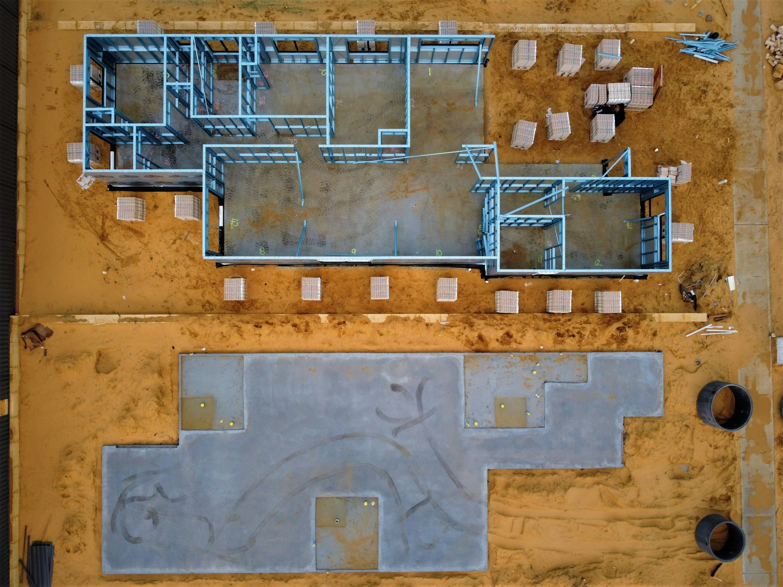
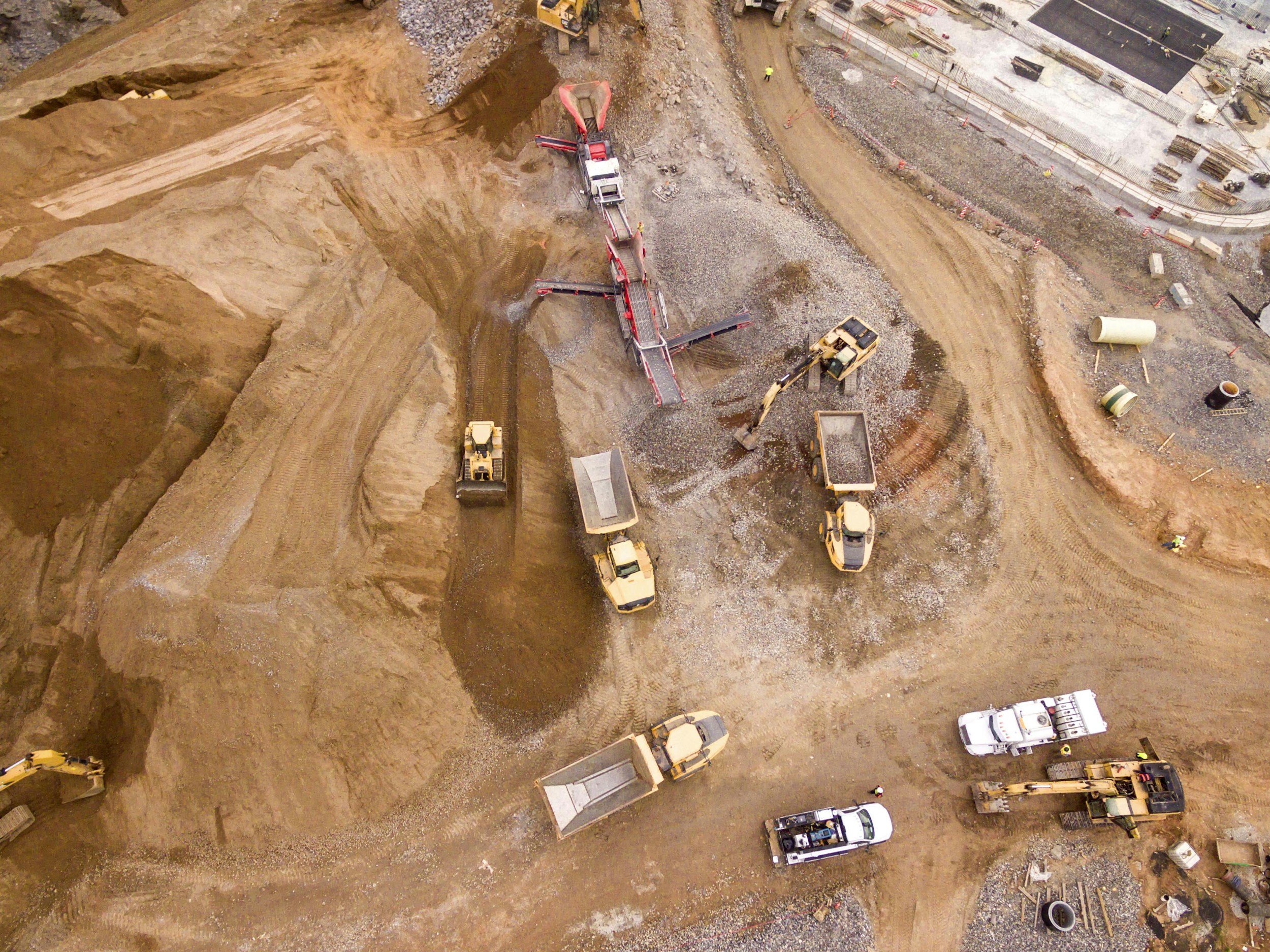
Construction & Inspection Services
At Artz Drones, we provide accurate, high-resolution aerial data to support construction, infrastructure, and site development projects.
Using RTK-enabled enterprise drones, we capture detailed imagery that delivers centimeter-level precision for progress monitoring, 3D modeling, and volumetric analysis.Our services help project managers and contractors:
Monitor site progress safely and efficiently
Track materials and stockpile volumes
Document job site conditions for compliance and reporting
Identify issues early to reduce costly delays
We deliver the aerial insights you need to stay on schedule, improve safety, and make informed project decisions.
ARTZ-DRONES


Our Enterprise Drone Fleet
At Artz-Drones LLC, we provide professional aerial mapping, imaging, and data-capture services using enterprise-grade drone technology. Our services include high-resolution orthomosaic mapping, RTK-enabled data collection, 3D modeling, thermal imaging, and multispectral analysis to support construction, agriculture, cemeteries, golf courses, and property management projects. Every mission is carefully planned and executed with precision to deliver accurate, actionable aerial data that helps clients make informed decisions.
DJI Mavic 3E – Precision Mapping
High-Resolution Imaging: Equipped with a large 4/3 CMOS sensor and a mechanical shutter, the Mavic 3E captures distortion-free images ideal for high-accuracy 2D and 3D maps.
RTK Compatibility: Delivers centimeter-level accuracy through its RTK module, making it perfect for surveying, construction, and detailed site mapping.
Extended Flight Time: Up to 45 minutes per flight, allowing large areas to be mapped efficiently in a single mission.
DJI Mavic 3T – Thermal & Visual Inspection
Thermal Imaging Power: Features a 640 × 512 thermal camera that identifies heat variations for irrigation, building, and turf analysis.
Dual Vision: Simultaneous thermal and RGB viewing enhances situational awareness and ensures thorough inspections.
Lightweight & Portable: Compact design enables rapid deployment for emergency response or spot inspections.
DJI Mavic 3M – Multispectral Analysis
Multispectral Sensors: Captures data in visible and near-infrared bands, enabling precise NDVI and vegetation health analysis for turf, forestry, and agriculture.
Real-Time Insights: Generates instant NDVI overlays for on-site decisions about fertilization, irrigation, and pest control.
RTK-Enabled Precision: Combines multispectral imaging with RTK positioning for ultra-accurate vegetation and land management.
DJI Matrice 4E – Heavy-Duty Performance
Industrial-Grade Mapping: Built for large-scale operations, the Matrice 4E offers extended range, enhanced stability, and advanced obstacle avoidance for demanding environments.
Advanced Payload Options: Ideal for surveying, construction, and infrastructure inspections.
All-Weather Reliability: Designed for rugged field conditions, ensuring consistent data collection even in challenging environments.
The Artz Drones Advantage
By combining the capabilities of the Mavic 3E, 3T, 3M, and Matrice 4E, we deliver a complete suite of aerial solutions that meet the needs of any project:
Accuracy: Centimeter-level RTK positioning ensures precision in every capture.
Efficiency: Extended flight times and automated missions streamline large-scale surveys.
Versatility: From thermal inspections to multispectral turf analysis, our fleet handles it all.
Professional Results: High-quality imagery and data products suitable for surveying, management, and client reporting.
At Artz Drones, our technology isn’t just about flight — it’s about delivering actionable data that helps you see clearer, decide smarter, and work more efficiently.
ARTZ-DRONE LLC
My name is Jose Rodriguez, and I’m an FAA Part 107 Certified Commercial Drone Pilot and founder of Artz-Drone LLC.
Together with my wife, we run a dedicated husband-and-wife business specializing in professional aerial mapping and analysis services designed to meet the unique needs of each client.
Our Specialties
📍 Mapping Services
High-resolution 2D orthomosaic maps and 3D surface models for accurate course and property analysis.
📸 Progress Reporting
Weekly or monthly progress reports with detailed before-and-after imagery, project overlays, and visual documentation to track ongoing work.
🌿 Turf Health & Thermal Assessments
Detect temperature variations across greens and fairways to identify overwatering, underwatering, or early signs of turf disease.
Use thermal imaging to pinpoint irrigation leaks or blockages, ensuring efficient water use and healthier turf.
Our drone technology delivers actionable insights that streamline maintenance, reduce environmental impact, and maintain exceptional course conditions for members and visitors alike.
Additional Benefits
Comprehensive data reports that are clear, visual, and easy to interpret.
Secure web access for real-time data viewing and on-site decision-making.
Jose Rodriguez
Founder, Artz-Drones LLC
📧 joserodriguez@artz-drones.com
📞 929-662-0752
🎥 YouTube.com/@artz-drones